Matthew 2:20 - Saying, Arise, and take the young child and his mother, and go into the land of Israel for they are dead which sought the young child's life.
The New Testament - A Brief Overview
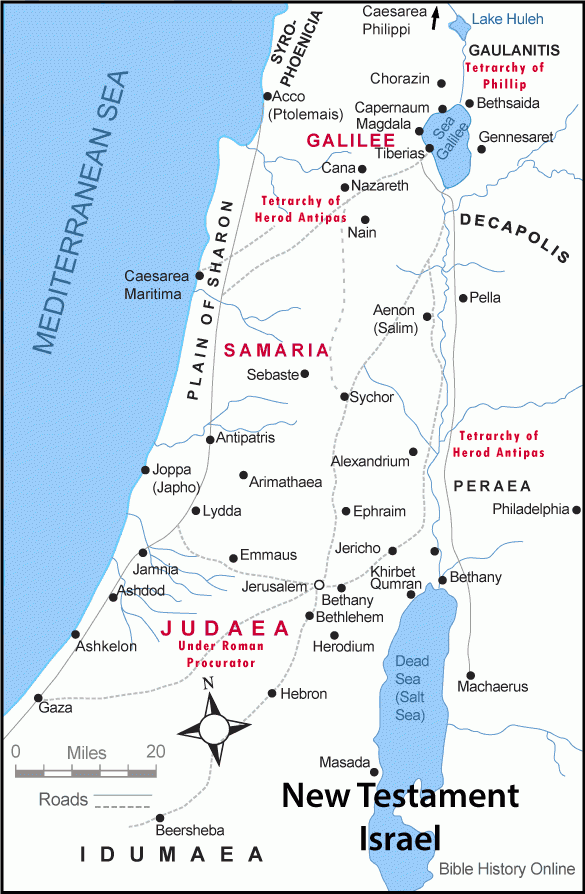
Map of Israel During the New Testament
During the time of Jesus and the New Testament Israel was under Roman administration. After Herod the Great died Caesar Augustus had appointed Herod Phillip as Tetrarch of Ituraea and Trachonitis. Herod Antipas was given the Tetrarchy of upper and lower Galilee, and the district of Peraea. Idumaea, Judea, and Samaria was given to Herod Archelaus but later Archelaus, was banished by the Roman government, when Pontius Pilate became procurator of the new Imperial province of Judea.
The Geography of Israel During New Testament Times.
On the west side of the Jordan River Israel was nearly 150 miles from north to south, and from east to west it was 20 miles in northern Israel and 60 miles in southern Israel. The total square miles of Israel was around 6,000 square miles west of the Jordan and 4,000 square miles east of the Jordan.
The Jordan Valley was a deep chasm in the earth dividing the land. In northern Galilee the mountains that the Jordan River runs through are around 4,000 feet above sea level, and in the south the Jordan descends to about 2,600 feet below sea level at the southern end of the Dead Sea. That is an incredible descent.
On the west side of the Jordan River are the "Shephelah" or fertile foothills which comes down from the mountains of Lebanon. West of the foothills are smaller sand hills with beautiful lush plains along the coast. There were no natural harbors along the coast of Israel.
Israel had 3 main regions: Galilee in the north, Samaria in the middle, and Judaea in the south.
In Galilee there was upper Galilee and lower Galilee. Upper Galilee had many mpountain ranges averaging around 4,000 feet. Lower Galilee had smaller hills of 1,000 feet. The very fertile Plain of Esdralon and Valley of Megiddo was in Lower Galilee. The main cities in Galilee mentioned in the Bible were Nazareth, Cana, Capernaum, and far to the north was Caesarea Philippi.
Samaria had many rugged mountains of around 2500 feet. The Biblical cities in Samaria were mainly Sebaste, and Sychor.
Judea has a hill country and then lowers down to Beersheba in the south about 1,000 feet above sea level. The desert in the South is a plateau that rises about 500 feet above sea level, and is very barren. But the mountains in this region had much water. The cities of Judea mentioned in the Bible were mainly Jerusalem, Bethany, Jericho, Bethlehem, Emmaus, and to the South was Hebron and Masada.
East of the Jordan River are the mountains of Bashan which rise about 1500 feet above sea level, and very good for farming. Going southward the mountains rise to over 3500 feet above sea level, with a great view overlooking the Western portion of Israel.
Numbers 33:51-53 - Speak unto the children of Israel, and say unto them, When ye are passed over Jordan into the land of Canaan; Then ye shall drive out all the inhabitants of the land from before you, and destroy all their pictures, and destroy all their molten images, and quite pluck down all their high places: And ye shall dispossess [the inhabitants] of the land, and dwell therein: for I have given you the land to possess it.