1599 Geneva Bible (GNV)
The Geneva Bible: A Cornerstone of English Protestantism A Testament to Reform The 1599 Geneva Bible... Read More
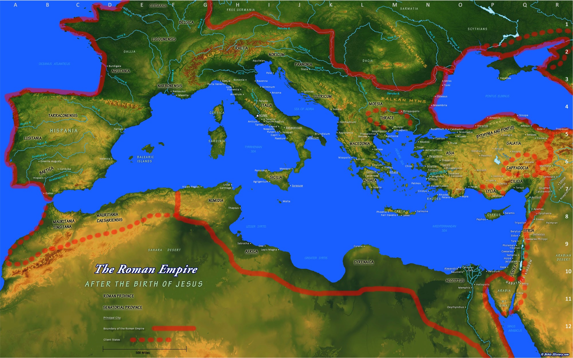
Po River
H-2 on the Map
Ancient Po River The ancient name was the Padus river. It was a large river which flowed down from the Alps and easterly through Gaul north of Italy and into the Adriatic Sea by several mouths. It was mentioned by Polybius and Pliny the Elder.
Padus River. Now the Po; the chief river of Italy, identified by the Roman poets with the fabulous Eridănus, from which amber was obtained. This notion appears to have arisen from the Phoenician vessels receiving at the mouths of the Padus the amber which had been transported by land from the coasts of the Baltic to those of the Adriatic. The name is said to be derived from the Keltic padi, “pine-tree” (Pliny , Pliny H. N. iii. 122). By the Ligurians it was called Bodencus. The Padus rises on Mount Vesula (Monte Viso), in the Alps, and flows in an easterly direction through the great plain of Cisalpine Gaul, which it divides into two parts, Gallia Cispadana and Gallia Transpadana. It receives numerous affluents, which drain the whole of this vast plain, descending from the Alps on the north and the Apennines on the south. These affluents, increased in the summer by the melting of the snow on the mountains, frequently bring down such a large body of water as to cause the Padus to overflow its banks. The whole course of the river, including its windings, is about 450 miles. About twenty miles from the sea the river divides itself into two main branches, and falls into the Adriatic Sea by several mouths (the ancients enumerated seven), between Ravenna and Altinum. Strabo believed the Padus to be the largest river in Europe after the Danube, and Vergil calls it fluviorum rex (Georg. i. 482). - Harry Thurston Peck. Harpers Dictionary of Classical Antiquities. New York. Harper and Brothers. 1898.
The Po River (Latin: Padus and Eridanus, Italian: Po [ˈpɔ], ancient Ligurian: Bodincus or Bodencus, Greek: Ἠριδανός) is a river that flows either 652 km (405 mi) or 682 km (424 mi) – considering the length of the Maira, a right bank tributary – eastward across northern Italy, from a spring seeping from a stony hillside at Pian del Re, a flat place at the head of the Val Po under the northwest face of Monviso (in the Cottian Alps) through a delta projecting into the Adriatic Sea near Venice. It has a drainage area of 74,000 km² in all, 70,000 in Italy, of which 41,000 is in montane environments, 29,000 on the plain,[2] and is the longest river in Italy. Its widest width is 503 m (1,650 ft).[1] The Po extends along the 45th parallel north. The river flows through many important Italian cities, including Turin (Torino), Piacenza and Ferrara. It is connected to Milan through a net of channels called navigli, which Leonardo da Vinci helped design. Near the end of its course, it creates a wide delta (with hundreds of small channels and five main ones, called Po di Maestra, Po della Pila, Po delle Tolle, Po di Gnocca and Po di Goro) at the southern part of which is Comacchio, an area famous for eels. The Po valley was the territory of the Roman Cisalpine Gaul, divided in Cispadane Gaul (South of the Po) and Transpadane Gaul (North of the Po). - Wikipedia
Maps are essential for any serious study, they help students of Roman history understand the geographical locations and historical backgrounds of the places mentioned in historical sources.
Map of New Testament Israel | Map of Old Testament Israel
Map of the Roman Empire | Bible History Online
Mention by Polybius. The Po is first certainly identified in the Graeco-Roman historians and geographers of the late Roman Republic and the early Roman Empire, long after the valley had been occupied successively by prehistoric and historic peoples: Ligures, Etruscans, Celts, Veneti, Umbri, and Romans. At that late date the ancient authors were attempting to explain the provenance of the name. Perhaps the earliest of these, Polybius[17] (2nd century BC), uses Pados (in Greek) and says that it was to be identified with the Eridanos of the poets. Moreover, the country people call it Bodencus.
This implies that a "country" population either remained from prehistoric times or adopted the name in use by that substrate. The name has been segmented as Bod-encus or Bod-incus, the suffix being characteristic of the ancient Ligurian language of northern Italy, southern France, Corsica and elsewhere.[18]
Mention by Pliny the Elder. Pliny the Elder has the most to say about the Padus of his times. Herodotus had expressed doubt concerning the existence of a river in Europe, Eridanos, which flowed into the northern sea, he said, from which amber came.[19] He believed it was a Greek name (there are other Eridanos rivers in Greece), "invented by some poet," but makes no conjectures as to where it might be. Pliny points out that in his own time the Eridanos had become wrongly identified with the Padus. He does not know when or how, but like Herodotus he blames the poets.[20] Amber is supposed to have come from there. Phaëthon, son of the sun, struck by lightning changed into poplars and exuded tears every year, which is the source of amber (a myth of Pausanias). Expressing surprise at the ignorance of the poets, Pliny says "There can be no doubt that amber is the product of the islands of the northern ocean (Baltic Sea)" and attributes its introduction into the Po valley to the Veneti, the last link in a trade route to the north through Pannonia and Germany. Pliny (Hist. Nat., iii. 122) also gives the Ligurian name of the Po river as Bodincus, which he translates as "bottomless". The root bod- has been generally analyzed as containing the PIE base *bhu(n)d(h)- seen in Sanskrit budhnah and Avestan buna- "bottom", Greek pythmen "foundation", Latin fundus "bottom", Old Irish bond "sole of the foot". The word Bodincus appears in the place name Bodincomagus, a Ligurian town on the right bank of the Po downstream from today’s Turin. - Wikipedia
PADUS
PADUS (Πάδος: Po), the principal river of Northern Italy, and much the largest river in Italy altogether. Hence Virgil calls it “fluviorum rex” (Georg. 1.481), and Strabo even erroneously terms it the greatest river in Europe after the Danube. (Strab. iv. p.204.) It has its sources in the Monte Viso, or Mons Vesulus, one of the highest summits of the Western Alps (Plin. Nat. 3.16. s. 20; Mel. 2.4.4). and from thence to the Adriatic has a course of above 400 miles. Pliny estimates it at 300 Roman miles without including the windings, which add about 88 more. (Plin. Nat. 3.16. s. 20.) Both statements are beneath the truth. According to modern authorities its course, including its windings, is calculated at 380 Italian, or 475 Roman miles. (Rampoldi, Diz. Topogr. d'Italia, vol. iii. p. 284.) After a very short course through a mountain valley it descends into the plain a few miles from Saluzzo, and from thence flows without interruption through a plain or broad level valley all the way to the sea. Its course from Saluzzo, as far as Chi vasso (through the district of the ancient Vagienni and Taurini), is nearly NE ; but after rounding the hills of the Monferrat, it turns due E., and pursues this course with but little variation the whole way to the Adriatic. The great plain or valley of the Po is in fact one of the most important physical features of Italy. Bounded on the N. by the Alps, and on the S. by the Apennines, both of which ranges have in this part of their course a general direction from W. to E., it forms a gigantic trough-like basin, which receives the whole of the waters that flow from the southern slopes of the Alps and the northern ones of the Apennines. Hence, as Pliny justly observes (l.c.), there is hardly any other river which, within the same space, receives so many and such important tributaries. Those from the north, on its left bank, are the most considerable, being fed by the perpetual snows of the Alps; and many of these form extensive lakes at the points where they first reach the plain; after quitting which they are deep and navigable rivers, though in some cases still very rapid. Pliny states that the Padus receives in all thirty tributary rivers, but it is difficult to know which he reckons as such; he himself enumerates only seventeen; but this number can be increased almost indefinitely, if we include smaller streams. The principal tributaries will be here enumerated in order, beginning from the source, and proceeding alone the left bank. They are: 1. the Clusius (Chiusone), not noticed by Pliny, but the name of which is found in the Tabula; 2. the DURIA commonly called Duria Minor, or Dora Riparia ; 3. the STURA (Stura); 4. the Orgus (Orco); 5. the DURIA MAJOR, or Bantica (Dora Baltea), one of the greatest of all the tributaries of the Padus ; 6. the SESITES (Sesia) ; 7. the TICINUS (Ticino), flowing from the Lacus Verbanus (Lago Maggiore); 8. the LAMBER or LAMBRUS (Lambro), a much less considerable stream, and which does not rise in the high Alps; 9. the ADDUA (Adda), flowing from the Lacus Larius or Lago di Como; 10. the OLLIUS (Oglio), which flows from the Lacus Sebinus (Lago d'Iseo), and brings with it the tributary waters of the Mela (Mella) and Clusius (Chiese); 11. the MINCIUS (Mincio), flowing from the Lago di Garda, or Lacus Benacus. Below this the Po cannot be said to receive any regular tributary; for though it communicates at more than one point with the Tartareo and Adige (Athesis),the channels are all artificial and the bulk of the waters of the Adige are carried out to the sea by their own separate channel. [ATHESIS]
On the southern or right bank of the Padus its principal tributaries are: 1. the TANARUS (Tanaro), a large river, which has itself received the important tributary streams of the Stura and Bormida, so that it brings with it almost all the waters of the Maritime Alps and adjoining tract of the Ligurian Apennines ; 2. the Scrivia, a considerable stream, but the ancient name of which is unknown; 3. the TREBIA (Trebbia), flowing by Placentia; 4. the Tarus (Taro); 5. the Nicia (Enza); 6. the Gabellus of Pliny, called also Secia (Secchia); 7. the SCULTENNA now called the Panaro; 8. the RHENUS (Reno), flowing near Bologna. To these may be added several smaller streams, viz.: the Idex (Idice), Silarus (Sillaro), Vatrenus (Plin., now Santerno), and Sinnus (Sinno), all of which discharge themselves into the southern arm of the Po, now called the Po di Primaro, and anciently known as the Spineticum Ostium, below the point [p. 2.510]where it separates from the main stream. Several smaller tributaries of the river in the highest part of its course are noticed in the Tabula or by the Geographer of Ravenna, which are not mentioned by any ancient author; but their names are for the most part corrupt and uncertain.
Though flowing for the most part through a great plain, the Padus thus derives the great mass of its waters directly from two great mountain ranges, and the consequence is that it is always a strong, rapid, and turbid stream, and has been in all ages subject to violent inundations. (Verg. G. 1.481; Plin. l.c.) The whole soil of the lower valley of the Po is indeed a pure alluvial deposit, and may be considered, like the valley of the Mississippi or the Delta of the Nile, as formed by the gradual accumulation of mud, sand, and gravel, brought down by the river itself and its tributary streams. But this process was for the most part long anterior to the historical period; and there can be no doubt that this portion of Italy had already acquired very much its present character and configuration as early as the time of the first Etruscan settlements. The valley of the Padus, as well as the river itself, are well described by Polybius (the earliest extant author in whom the Roman name of Padus is found), as well as at a later period by Strabo and Pliny. (Pol. 2.16; Strab. iv. pp. 203, 204, v. p. 212; Plin. Nat. 3.16. s. 20.) Considerable changes have, however, taken place in the lower part of its course, near the Adriatic sea. Here the river forms a kind of great delta, analogous in many respects to that of the Nile; and the phenomenon is complicated, as in that case, by the existence of great lagunes bordering the coast of the Adriatic, which are bounded by narrow strips or bars of sand, separating them from the sea, though leaving open occasional channels of communication, so that the lagunes are always salt and affected by the tides, which are more sensible in this part of the Adriatic than in the Mediterranean. (Strab. v. p.212.) These lagunes, which are well described by Strabo, extended in his time from Ravenna to Altinum, both of which cities stood in the lagunes or marshes, and were; built, on piles, in the same manner as the modern Venice. But the whole of these could not be fairly considered as belonging to the Delta of the Padus; the more northerly being formed at the mouths of other rivers, the Athesis, Meduacus, &c., which had no direct or natural communication with the great river. They all, however, communicated with the Padus, and with one another, by channels or canals more or less artificial; and as this was already the case in the time of Pliny, that author distinctly reckons the mouths of the Padus to extend from Ravenna to Altinum. (Plin. l.c.) From the earliest period that this tract was occupied by a settled people, the necessity must have been felt of embanking the various arms and channels of the river, for protection against inundation, as well as of constructing artificial cuts and channels, both for carrying off its superfluous waters and for purposes of communication. The earliest works of this kind are ascribed to the Etruscans (Plin. l.c.), and from that time to the present day, they have been carried on with occasional interruptions. But in addition to these artificial changes, the river has from time to time burst its banks and forced for itself new channels, or diverted the mass of its waters into those which were previously unimportant. The most remarkable of these changes which is recorded with certainty, took place in 1152, when the main stream of the Po, which then flowed S. of Feerara, suddenly changed its course, and has ever since flowed about 3 miles N. of that city. Hence it is probable that all the principal modern mouths of the Po, front the Po di Goro to the Po di Levante, were in ancient times comparatively inconsiderable.
Polybius (2.16) describes the Padus as having only two principal mouths, which separated at a place called Trigaboli (the site of which cannot be determined); the one of these is called by him Padoa (Παδόα), and the other, which was the principal channel, and the one commonly navigated, he calls Olana or Holana (Ὅλανα). This; last is in all probability the channel still called Po di Volano, which until the great inundation of 1152, above noticed, was still the principal mouth. of the Po. The other is probably the southernmost branch of the river, which separates from the preceding at. Ferrara, and is carried at the present day by a wholly artificial channel into the sea at Primaro, from whence it derives the name of Po di Primaro. Its present mouth is about 15 miles N. of Ravenna; but it seems that in the days of Pliny, and probably in those of Polybius also, it discharged itself into the lagunes which then surrounded Ravenna on all sides. Pliny terms it Padusa, but gives it also the name of Fossa Augusta, from its course having been artificially regulated, and perhaps altered, by that emperor. (Plin. Nat. 3.16. s. 20.) The same author gives us a detailed enumeration of the mouths of the Padus as they existed in his day, but from the causes of change already adverted to, it is very difficult, if not impossible, to identify them with certainty.
They were, according to him: 1. the PADUSA or Fossa Augusta, which (he adds) was previously called Messanicus: this has now wholly ceased to exist. 2. The PORTUS VATRENI, evidently deriving its name from being the mouth of the river Vatrenus, which flowed from Forum Cornelii, just as the Po di Primaro is at the present day called the mouth of the Reno. This was also known as the Spineticum Ostium, from the once celebrated city of Spina, which was situated on its banks [SPINA]. It was probably the same with the modern Po di Primaro. 3. Ostium Caprasiae. 4. Sagis. 5. Volana, previously called Olane: this is evidently the Olana of Polybius, and the modern Po di Volano; the two preceding cannot be identified, but must have been openings communicating with the great lagunes of Comacchio. 6. The Carbonaria, perhaps the Po di Goro. 7. The Fossio Philistina, which seems to have been an artificial canal, conveying the waters of the TARTARUS still called Tartaro, to the sea. This cannot be identified, the changes of the mouths of the river in this, part being too considerable. The whole of the present delta, formed by the actual mouths of the Po (from. the Po di Goro to the Po di Levante), must have been formed since the great change of 1152; its progress for some centuries back can be accurately traced; and we know that it has advanced not less than 9 miles in little more than two centuries and a half, and at least 15 miles since the 12th century. Beyond this the delta belongs rather to the Adige, and more northern streams, than to the Po; the next mouth being that of the main stream of the Adige itself, and just. beyond it the Porto. di Brondolo (the Brundulus Portus of Pliny), which at the present day is the mouth of the Brenta.1 [p. 2.511]
The changes which have taken place on this lin of coast are due not only to the pushing forward of the coast-line at the actual mouths of the rivers, but to the filling up of the lagunes. These in ancient times extended beyond Ravenna on the S.; but that city is now surrounded on all sides by dry land, and the lagunes only begin to the N. of the Po di Primaro. Here the lagunes of Comacchio extend over a space of above 20 miles in length, as far as the mouth of the Po di Volano; but from that point to the fort of Brondolo, where the Venetian lagunes begin, though the whole country is very low and marshy, it is no longer covered with water, as it obviously was at no distant period. It is now therefore, impossible to determine what were the particular lagunes designated by Pliny as the SEPTEM MARIA and indeed the passage in which he alludes to them is not very clear; but as he calls them Atrianorum Paludes, they would seem to have been in the neighbourhood of Adria, and may probably have been the extensive lagunes (now converted into marshes) S. of Ariano. At a later period the name seems to have been differently used. The Itinerary speaks of the navigation “per Septem Maria [a Ravenna] Altinum usque,” so that the name seems here to be applied to the whole extent of the lagunes; and it is employed in the same sense by Herodian (8.7); while the Tabula, on the contrary,gives the name to a particular point or station on the line of route from Ravenna to Altinum. This line, which is given in much detail, must have been by water, though not so specified, as there never could have been a road along the line in question; but it is impossible to identify with any certainty the stations or points named. (Itin. Ant. p. 126; Tab. Peut.) [VENETIA]
Polybius speaks of the Padus as navigable for a distance of 2000 stadia, or 250 Roman miles from the sea. (Pol. 2.16.) Strabo notices it as navigable from Placentia downwards to Ravenna, without saying that it was not practicable higher up: and Pliny correctly describes it as beginning to be navigable from Augusta Taurinorum (Turin), more than 120 miles above Placentia. (Strab. v. p.217; Plin. Nat. 3.17. s. 21.) Ancient writers already remarked that the stream of the Padus was fuller and more abundant in summer than in winter or spring, owing to its being fed in great part by the melting of the snows in the high Alps. (Pol. 2.16; Plin. Nat. 3.16. s. 20.) It is not till after it has received the waters of the Duria Major or Dora Baltea, a stream at least as considerable as itself, that the Po becomes a really great river. Hence, it is about this point (as Pliny observes) that it first attains to. a considerable depth. But at the present day it is not practicable for vessels of any considerable burden above Casale, about 25 miles lower down.
The origin of the name of Padus is uncertain. According to Metrodorus of Scepsis (cited by Pliny, l.c.), it was a Celtic name, derived from the number of pine-trees which grew around its sources. The etymology seems very doubtful; but the fact that the name was of Celtic origin is rendered probable by the circumstance that, according both to Polybius and Pliny, the name given it by the Ligurians (the most ancient inhabitants of its banks) was Bodincus or Bodencus (Βόδεγκος, Pol. 2.16; Plin. Nat. 3.16. s. 20), a name said to be derived from its great it depth. It is well known that it was early identified it by the Greeks with the mythical ERIDANUS and was commonly called by them, as well as by the Latin poets, by that name, even at a late period. The origin and history of this name have been already given in the article ERIDANUS It may be added, that the poplar trees which figure in the fable of Phaëton (in its later form) evidently refer to the tall and graceful trees, still commonly known as Lombardy poplars, from their growing in abundance on the banks of the Po. - Dictionary of Greek and Roman Geography (1854) William Smith, LLD, Ed.

Unearth the rich tapestry of biblical history with our extensive collection of over 1000 meticulously curated Bible Maps and Images. Enhance your understanding of scripture and embark on a journey through the lands and events of the Bible.
Start Your Journey Today!